数据说明
数据说明
Sentinel 2(哨兵2) 的波段共有 13 个,每个波段的像素大小为 10、20 或 60 米不等。Sentinel 2 由 2 颗卫星组成: 第一个是 2015 年发行的 Sentinel 2A 卫星,另一个是 2017 年发行的 Sentinel 2B 卫星。另外两颗卫星(Sentinel 2C 和 2D)计划于 2024 年发射,总计共四颗 Sentinel-2 卫星。总体而言,这 2 颗额外的卫星将会把重访时间缩短一半。
一个典型的SAFE文件夹结构可能如下所示:
S1A_IW_SLC__1SDV_20210726T214323_20210726T214355_038954_0498A8_4D2A.SAFE
├── manifest.safe
├── measurement
│ └── s1a-iw-slc-vv-20210726t214323-20210726t214355-038954-0498a8-001.tiff
├── annotation
│ ├── s1a-iw-slc-vv-20210726t214323-20210726t214355-038954-0498a8-001.xml
│ └── calibration
│ └── s1a-iw-slc-vv-20210726t214323-20210726t214355-038954-0498a8-001.cal.xml
└── auxiliary
└── s1a-aux-poeorb-20210726t214323-20210726t214355-038954-0498a8-001.aux.xml
哨兵2号卫星光谱信息
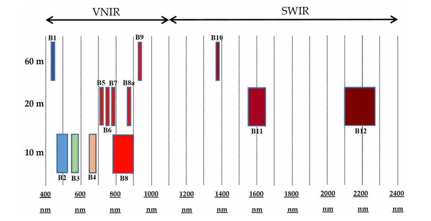
Sentinel-2 携带多光谱成像仪(MSI),该传感器提供13个光谱波段,像素大小范围从 10 到 60 米。
蓝色 (B2)、绿色 (B3)、红色 (B4) 和近红外 (B8) 波段具有 10 米的分辨率;
红端(B5)、近红外 NIR(B6、B7 和 B8A)以及短波红外 SWIR(B11和B12)的地面采样距离为20米;
沿海大气气溶胶 (B1) 和卷云波段 (B10) 的像素大小为 60 米;
| 名称 | 波长(nm) | 分辨率(m) | 比例因子 | 值域范围 | 描述信息 | |
|---|---|---|---|---|---|---|
| S2A | S2B | |||||
| B1 | 443.9 | 442.3 | 60 | 0.0001 | Aerosols | |
| B2 | 496.6 | 492.1 | 10 | 0.0001 | Blue | |
| B3 | 560 | 559 | 10 | 0.0001 | Green | |
| B4 | 664.5 | 665 | 10 | 0.0001 | Red | |
| B5 | 703.9 | 703.8 | 20 | 0.0001 | Red Edge 1 | |
| B6 | 740.2 | 739.1 | 20 | 0.0001 | Red Edge 2 | |
| B7 | 782.5 | 779.7 | 20 | 0.0001 | Red Edge 3 | |
| B8 | 835.1 | 833 | 10 | 0.0001 | NIR | |
| B8A | 864.8 | 864 | 20 | 0.0001 | Red Edge 4 | |
| B9 | 945 | 943.2 | 60 | 0.0001 | Water vapor | |
| B11 | 1613.7 | 1610.4 | 20 | 0.0001 | SWIR 1 | |
| B12 | 2202.4 | 2185.7 | 20 | 0.0001 | SWIR 2 | |
| AOT | 10 | 0.001 | Aerosol Optical Thickness | |||
| TCI | 10 | True Color Image | ||||
| WVP | 10 | 0.001 | Water Vapor Pressure. The height the water would occupy if the vapor were condensed into liquid and spread evenly across the column. | |||
| SCL | 20 | 1~11 | Scene Classification Map (The "No Data" value of 0 is masked out) | |||
| MSK_CLDPRB(CLD_20m) | 20 | 0~100 | Cloud Probability Map (missing in some products) | |||
| MSK_SNWPRB(SNW_20m) | 20 | 0~100 | Snow Probability Map (missing in some products) | |||
| CLM | 60 | Cloud mask | ||||

MSI spectral bands vs. spatial resolution with corresponding FullWidth at Half Maximum (FWHM). Source: F. Gascon, C. Bouzinac, O. Thépaut et al., “Copernicus Sentinel-2A Calibration and Products Validation Status,” Remote Sensing, 9(6), 584 (2017).
import numpy as np
from osgeo import gdal
filename = "../dataS2B_MSIL1C_20230622T023529_N0509_R089_T51STV_20230622T042653.SAFEMTD_MSIL1C.xml"
root_ds = gdal.Open(filename)
ds_list = root_ds.GetSubDatasets() # 获取子数据集。该数据以数据集形式存储且以子数据集形式组织
print(ds_list)
结果:ds_list包括4个数据子集
子集1:包含B2, B3, B4, B8
[('SENTINEL2_L1C:../dataS2B_MSIL1C_20230622T023529_N0509_R089_T51STV_20230622T042653.SAFEMTD_MSIL1C.xml:10m:EPSG_32651',
'Bands B2, B3, B4, B8 with 10m resolution, UTM 51N'),
子集2:包含B5, B6, B7, B8A, B11, B12
('SENTINEL2_L1C:../dataS2B_MSIL1C_20230622T023529_N0509_R089_T51STV_20230622T042653.SAFEMTD_MSIL1C.xml:20m:EPSG_32651',
'Bands B5, B6, B7, B8A, B11, B12 with 20m resolution, UTM 51N'),
子集3:包含B1, B9, B10
('SENTINEL2_L1C:../dataS2B_MSIL1C_20230622T023529_N0509_R089_T51STV_20230622T042653.SAFEMTD_MSIL1C.xml:60m:EPSG_32651',
'Bands B1, B9, B10 with 60m resolution, UTM 51N'),
子集4:可见光3个波段
('SENTINEL2_L1C:../dataS2B_MSIL1C_20230622T023529_N0509_R089_T51STV_20230622T042653.SAFEMTD_MSIL1C.xml:TCI:EPSG_32651',
'True color image, UTM 51N')]
visual_ds = gdal.Open(ds_list[0][0]) # 打开第1个数据子集的路径。ds_list有4个子集,内部前段是波段编号,后段是数据信息
visual_arr = visual_ds.ReadAsArray() # 将数据集中的数据读取为ndarray
band_count = visual_ds.RasterCount # 波段数
print(band_count) # 查看该子集中的波段数
print(visual_arr.shape) # 查看数组结构:(4, 10980, 10980)
# 植被指数(B8 - B4) / (B8 + B4)
# Bands:B2, B3, B4, B8
B8 = visual_arr[3, :, :]
B4 = visual_arr[2, :, :]
band_NIR = B8
band_R = B4
# (band_NIR.astype(np.float32) - band_R) / (band_NIR + band_R)
NDVI = (band_NIR - band_R) / (band_NIR + band_R)
根据官网(Products and Algorithms)介绍,
Level-0 是压缩的原始数据。Level-0 产品包含生成 Level-1(及更高)产品级别所需的所有信息。
Level-0 is compressed raw data. The Level-0 product contains all the information required to generate the Level-1 (and upper) product levels.
Level-1A 是未压缩的原始数据,带有粗略配准的光谱带和附加的辅助数据。
Level-1A is uncompressed raw data with spectral bands coarsely coregistered and ancillary data appended.
Level-1B 数据是经过辐射校正的辐射数据。物理几何模型使用可用的地面控制点进行细化并附加到产品,但未应用。
Level-1B data is radiometrically corrected radiance data. The physical geometric model is refined using available ground control points and appended to the product, but not applied.
注意:Level-0、Level-1A 和 Level-1B 产品不分发给用户。
Note: Level-0, Level-1A and Level-1B products are not disseminated to Users.
Level-1C 产品提供正射校正的大气层顶 (TOA) 反射率,具有亚像素多光谱配准。云和陆地/水掩膜包含在产品中。
Level-1C product provides orthorectified Top-Of-Atmosphere (TOA) reflectance, with sub-pixel multispectral registration. Cloud and land/water masks are included in the product.
Level-2A 产品提供正射校正的大气底部 (BOA) 反射率,具有亚像素多光谱配准。产品中包含场景分类图(云、云影、植被、土壤/沙漠、水、雪等)。
Level-2A product provides orthorectified atmospherically corrected Surface Reflactance, with sub-pixel multispectral registration. A Scene Classification map (cloud, cloud shadows, vegetation, soils/deserts, water, snow, etc.) is included in the product.
Level-1C 和 Level-2A 产品通过哥白尼数据空间 ( dataspace ) 提供给用户(见下两张网站截图 20240206)。
Level-1C and Level-2A products are made available to users via the Copernicus Open Access Hub (SciHub已经于2023年10月关闭,地址|网站截图,改为通过dataspace访问).

Level 1C data are data of sufficient quality for most investigations, where all image corrections were done except for the atmospheric correction. Data are available globally since June 2015 onwards.
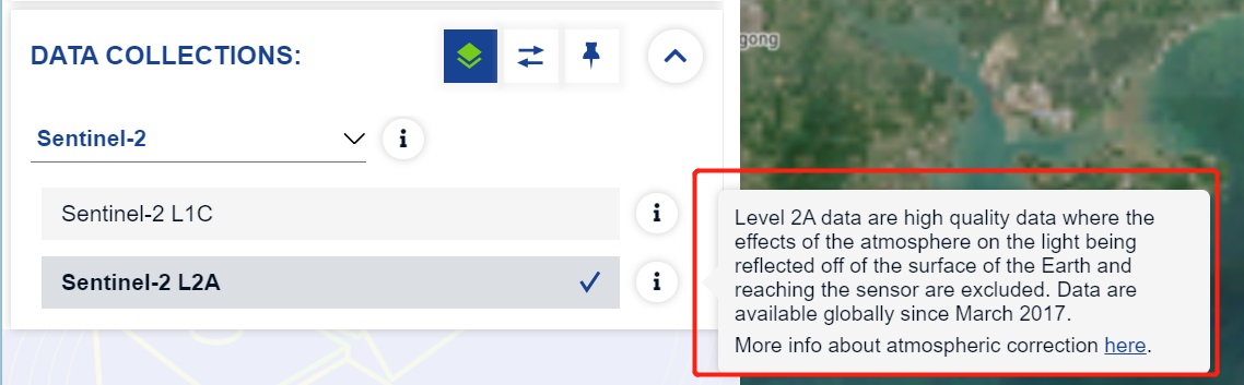
Level 2A data are high quality data where the effects of the atmosphere on the light being reflected off of the surface of the Earth and reaching the sensor are excluded. Data are available globally since March 2017. More info about atmospheric correction here.

哨兵2号卫星0级至2A级数据的获取、处理、备份和分发由哨兵地面控制部门(Sentinel-2 Ground Segment)。用户也可以利用哨兵2号工具箱(Sentinel-2 Toolbox)处理获得2A级产品。
哨兵2号的L1C产品是指经过几何精校正的产品,L2A是经过辐射校正的产品。
Level-1B、Level-1C和Level-2A。Level-1B为原始数据,Level-1B产品需要专业的矫正技术;Level-1C为已应用的辐射和几何校正(包括正射校正和空间配准),1C级图像是一组100平方公里的磁贴,每个磁贴约为500 MB;Level-2A为经过Sen2Cor进行大气校正和正射校正后的产品,作为CSC演进活动的一部分,目前正在评估从Sentinels核心地面部门系统提供标准核心产品的可能性。由于数据量大,考虑服务器压力,哨兵2号数据直接下载的时间跨度为一年半至今的数据,offline数据需要提交申请才可下载。


哨兵2号遥感影像数据空间分幅方式详解
Sentinel 2(哨兵2)卫星遥感数据的波段和组合介绍